Agisoft Metashape
Professional Photogrammetry Software for 3D Mapping & Modeling
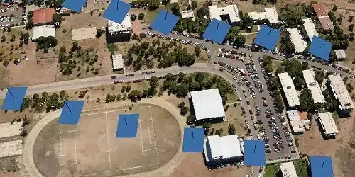
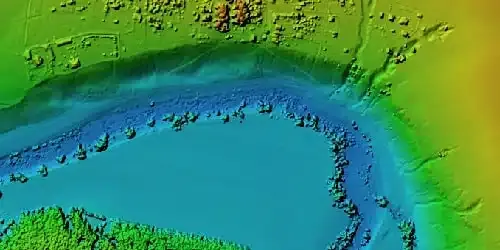
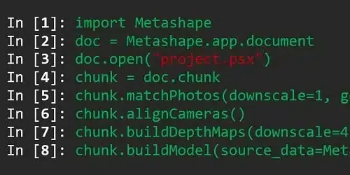
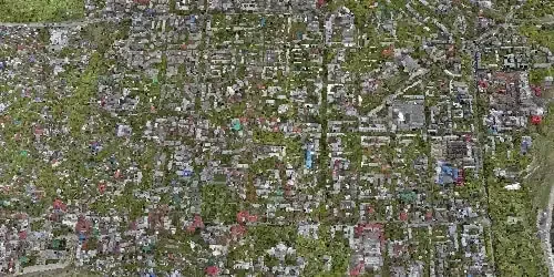
Agisoft Metashape is a leading photogrammetry software solution that transforms aerial and ground imagery into accurate 3D spatial data. Widely used across surveying, mining, construction, agriculture, archaeology, and public safety, it delivers precise point clouds, digital elevation models, textured 3D meshes, and orthomosaics. With scalable processing, automation features, and compatibility with drone and camera imagery, Metashape provides professionals with a robust toolset for geospatial analysis and digital twin creation.
Key Features
Photogrammetry & 3D Reconstruction
Survey & GIS Tools
Automation & Scalability
Visualization & Analysis
Data Management & Integration
In-The-Box
- Agisoft Metashape Perpetual License
Specs Sheet
Standard Edition
| Category | Specification |
| Core Function | 3D modeling, visualization, VR/AR content |
| Photogrammetry | Basic 3D reconstruction |
| Georeferencing | Not supported |
| Orthomosaic / DEM | Not supported |
| Automation / Scripting | Limited batch processing |
| Applications | VFX, game design, cultural heritage, creative 3D projects |
Core Function
3D modeling, visualization, VR/AR content
Photogrammetry
Basic 3D reconstruction
Georeferencing
Not supported
Orthomosaic / DEM
Not supported
Automation / Scripting
Limited batch processing
Applications
VFX, game design, cultural heritage, creative 3D projects
Professional Edition
| Category | Specification |
| Core Function | Surveying, GIS, mapping, scientific applications |
| Photogrammetry | Full suite, including multispectral and thermal |
| Georeferencing | Yes (supports GCPs, RTK/PPK, coordinate systems) |
| Orthomosaic / DEM | Yes (DSM, DTM, true orthomosaic generation) |
| Automation / Scripting | Full Python API and batch processing |
| Applications | Surveying, mining, construction, agriculture, archaeology, public safety |
Core Function
Surveying, GIS, mapping, scientific applications
Photogrammetry
Full suite, including multispectral and thermal
Georeferencing
Yes (supports GCPs, RTK/PPK, coordinate systems)
Orthomosaic / DEM
Yes (DSM, DTM, true orthomosaic generation)
Automation / Scripting
Full Python API and batch processing
Applications
Surveying, mining, construction, agriculture, archaeology, public safety
Input Data
| Category | Specification |
| Supported Imagery | Aerial, close-range, multispectral, thermal |
| Image Formats | JPEG, TIFF, PNG, RAW (various camera models) |
| Metadata | EXIF, GPS/IMU data |
| Control Data | GCPs, GPS log files, LiDAR integration (Pro edition) |
Supported Imagery
Aerial, close-range, multispectral, thermal
Image Formats
JPEG, TIFF, PNG, RAW (various camera models)
Metadata
EXIF, GPS/IMU data
Control Data
GCPs, GPS log files, LiDAR integration (Pro edition)
Processing Outputs
| Category | Specification |
| Point Clouds | Dense, colored, or classified point clouds |
| Mesh Models | Textured 3D mesh, polygonal models |
| Orthomosaic | True orthomosaic with high accuracy |
| Elevation Models | DEM, DSM, DTM |
| Measurements | Distance, area, volume calculations |
| Export Formats | LAS, LAZ, OBJ, FBX, PLY, DXF, GeoTIFF, KML, PDF |
Point Clouds
Dense, colored, or classified point clouds
Mesh Models
Textured 3D mesh, polygonal models
Orthomosaic
True orthomosaic with high accuracy
Elevation Models
DEM, DSM, DTM
Measurements
Distance, area, volume calculations
Export Formats
LAS, LAZ, OBJ, FBX, PLY, DXF, GeoTIFF, KML, PDF
Workflow & Integration
| Category | Specification |
| Automation | Batch processing, Python scripting API |
| Scalability | Supports cluster processing and cloud deployment |
| GIS Integration | Exports to ArcGIS, QGIS, AutoCAD, MicroStation |
| 3D/Creative Export | VR/AR, game engines, 3D printing compatible |
Automation
Batch processing, Python scripting API
Scalability
Supports cluster processing and cloud deployment
GIS Integration
Exports to ArcGIS, QGIS, AutoCAD, MicroStation
3D/Creative Export
VR/AR, game engines, 3D printing compatible
System Requirements
| Category | Specification |
| CPU | Minimum: Intel i5 or AMD equivalent Recommended: Multi-core Intel i7/i9 or AMD Ryzen |
| GPU | Minimum: 2 GB VRAM, OpenCL/CUDA support Recommended: 4–8 GB VRAM NVIDIA/AMD |
| RAM | Minimum: 16 GB Recommended: 32 GB+ |
| Storage | Minimum: 20 GB free space (SSD preferred) Recommended: SSD/NVMe with 100 GB+ for large datasets |
| OS | Minimum: Windows 7/8/10/11 (64-bit), macOS, Linux Recommended: Latest 64-bit OS with GPU acceleration |
CPU
Minimum:
Intel i5 or AMD equivalent
Recommended:
Multi-core Intel i7/i9 or AMD Ryzen
Intel i5 or AMD equivalent
Recommended:
Multi-core Intel i7/i9 or AMD Ryzen
GPU
Minimum:
2 GB VRAM, OpenCL/CUDA support
Recommended:
4–8 GB VRAM NVIDIA/AMD
2 GB VRAM, OpenCL/CUDA support
Recommended:
4–8 GB VRAM NVIDIA/AMD
RAM
Minimum:
16 GB
Recommended:
32 GB+
16 GB
Recommended:
32 GB+
Storage
Minimum:
20 GB free space (SSD preferred)
Recommended:
SSD/NVMe with 100 GB+ for large datasets
20 GB free space (SSD preferred)
Recommended:
SSD/NVMe with 100 GB+ for large datasets
OS
Minimum:
Windows 7/8/10/11 (64-bit), macOS, Linux
Recommended:
Latest 64-bit OS with GPU acceleration
Windows 7/8/10/11 (64-bit), macOS, Linux
Recommended:
Latest 64-bit OS with GPU acceleration
Licensing
| Category | Specification |
| License Type | Perpetual license |
| Activation | Node-locked or floating license |
| Platform Support | Windows, macOS, Linux |
| Updates | Free minor updates within version series |
License Type
Perpetual license
Activation
Node-locked or floating license
Platform Support
Windows, macOS, Linux
Updates
Free minor updates within version series
Get In Touch
Have questions? Our drone experts are here to help