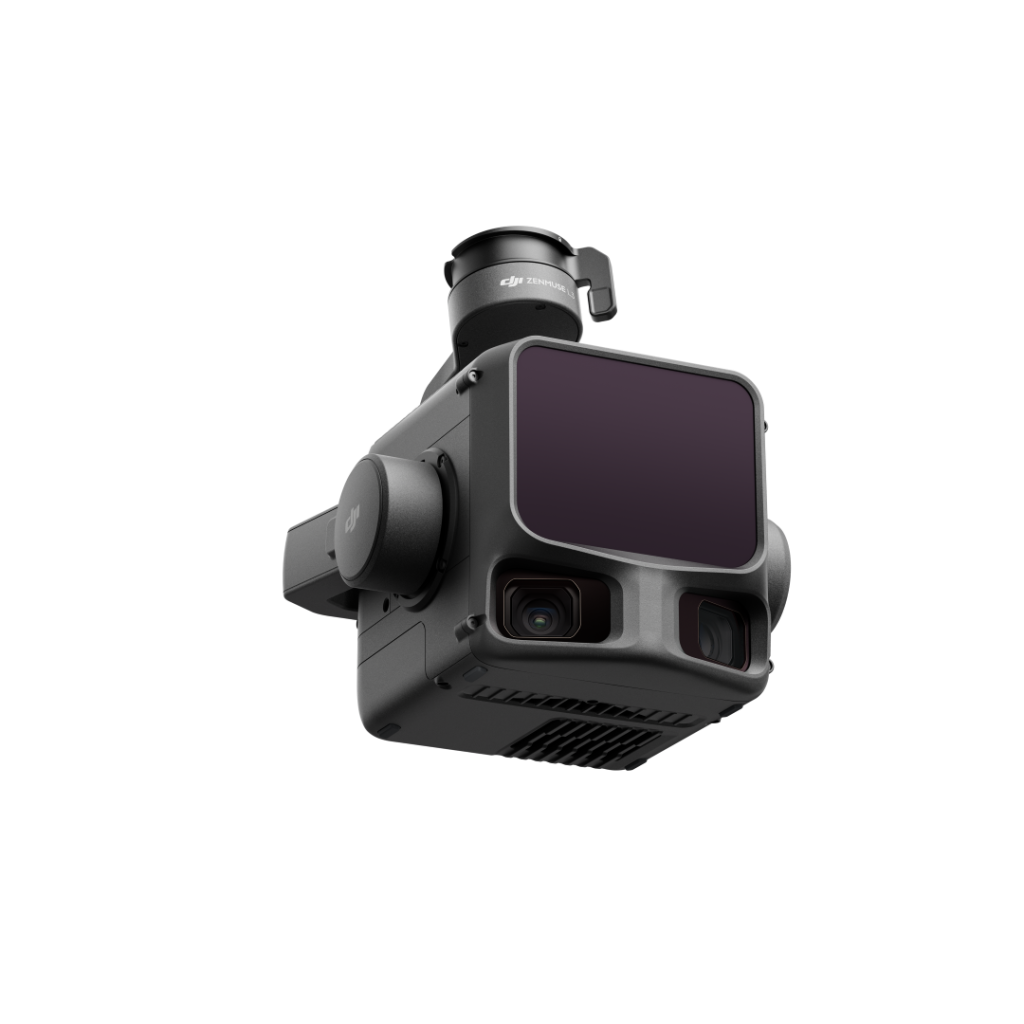
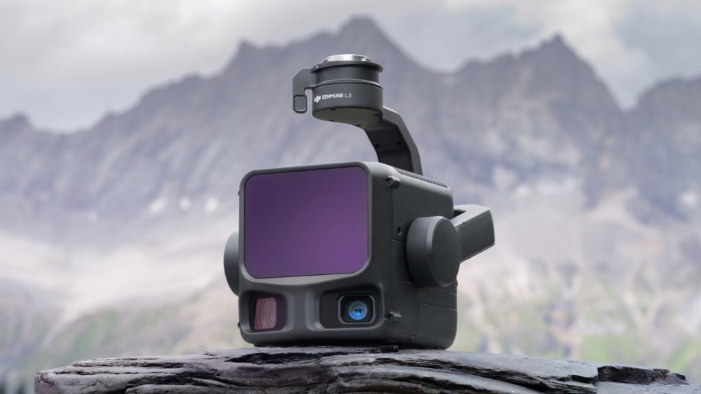
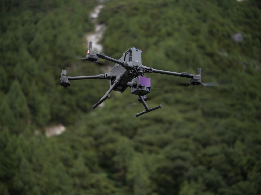
DJI Zenmuse L3
High-Performance LiDAR & Dual-RGB Payload for Aerial Surveying
DJI Zenmuse L3
The DJI Zenmuse L3 is an advanced LiDAR + dual-RGB payload engineered for high-precision aerial mapping and survey missions. With long-range LiDAR detection, dual RGB cameras for true-colour imaging, and a rugged IP54-rated body, it’s tailored for industrial applications including forestry, infrastructure inspection, mining, and topographic mapping.
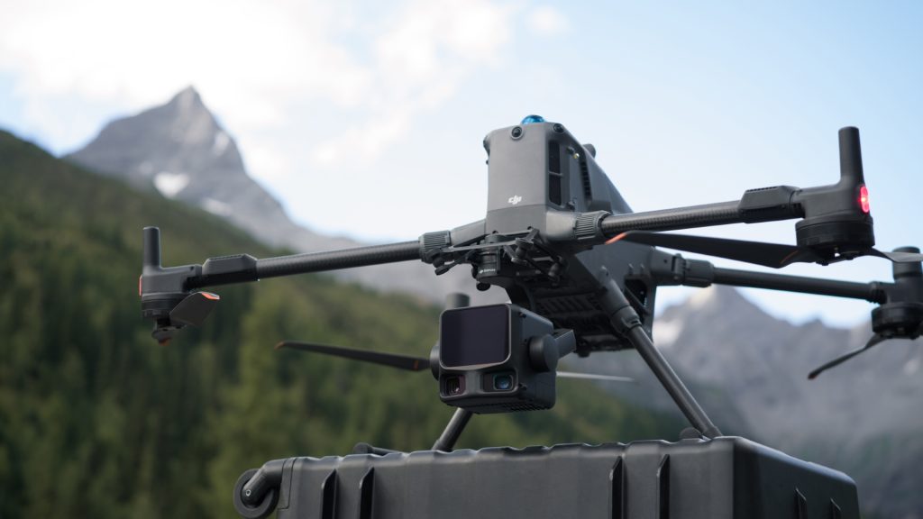
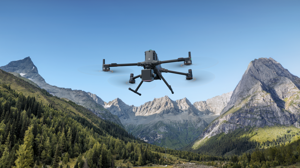
Built to mount on select DJI enterprise drones (like the Matrice 400 series), it enables professionals to capture dense point clouds, detailed orthophotos, and accurate 3D models with efficiency and reliability.
Key Features
Advanced LiDAR & Imaging
Survey-Grade Accuracy & Efficiency
Enterprise Drone Integration
Workflow Optimisation
In-The-Box
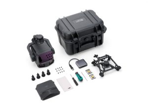
- Zenmuse L3 × 1
- Zenmuse L3 Lens Cap × 1
- CFexpress™ Type B Memory Card (1 TB) (brand may vary; actual product received prevails) × 2
- CFexpress™ Type B Card Reader × 1
- Zenmuse L3 Storage Case × 1
- Lens Cleaning Cloth × 1
- DJI Matrice 400 Carrying Case Insert (Zenmuse L3)
- Zenmuse L3 Single Gimbal Connector × 1
- Screws and Tools × 1
- Zenmuse L3 Gimbal Damper (4 pcs) × 1
Specs Sheet
General
| Category | Specification |
| Point Cloud System Accuracy (At 120m Flight Altitude) | Vertical Accuracy: 3 cm (RMSE) Horizontal Accuracy: 4 cm (RMSE) |
| Point Cloud System Accuracy (At 300m Flight Altitude) | Vertical Accuracy 5 cm (RMSE) Horizontal Accuracy: 7.5 cm (RMSE) |
| Point Cloud Thickness | 1.2 cm@1σ (120m nadir flight altitude) 2 cm@1σ (300m nadir flight altitude) |
| Combined Horizontal FOV (Dual RGB Mapping Cameras) | 107° |
| RGB Ground Sampling Distance (GSD) | Average Value: 3 cm (300m nadir flight altitude) |
| Weight | 1.60 kg (without single gimbal connector) |
| Dimensions | 192×162×202 mm (L×W×H) |
| Power | 64 W (typical) 100 W (max) |
| Supported Aircraft | DJI Matrice 400 (requires the Zenmuse L3 single gimbal connector) |
| Ingress Protection Rating | IP54 |
| Operating Temperature | -20° to 50° C (-4° to 122° F) |
| Storage Temperature | -40° to 70° C (-40° to 158° F) |
Point Cloud System Accuracy (At 120m Flight Altitude)
Vertical Accuracy: 3 cm (RMSE)
Horizontal Accuracy: 4 cm (RMSE)
Horizontal Accuracy: 4 cm (RMSE)
Point Cloud System Accuracy (At 300m Flight Altitude)
Vertical Accuracy 5 cm (RMSE)
Horizontal Accuracy: 7.5 cm (RMSE)
Horizontal Accuracy: 7.5 cm (RMSE)
Point Cloud Thickness
1.2 cm@1σ (120m nadir flight altitude)
2 cm@1σ (300m nadir flight altitude)
2 cm@1σ (300m nadir flight altitude)
Combined Horizontal FOV (Dual RGB Mapping Cameras)
107°
RGB Ground Sampling Distance (GSD)
Average Value: 3 cm (300m nadir flight altitude)
Weight
1.60 kg (without single gimbal connector)
Dimensions
192×162×202 mm (L×W×H)
Power
64 W (typical)
100 W (max)
100 W (max)
Supported Aircraft
DJI Matrice 400 (requires the Zenmuse L3 single gimbal connector)
Ingress Protection Rating
IP54
Operating Temperature
-20° to 50° C (-4° to 122° F)
Storage Temperature
-40° to 70° C (-40° to 158° F)
LiDAR
| Category | Specification |
| Laser Wavelength | 1535 nm |
| Laser Beam Divergence | 0.25 mrad (1/e²) |
| Laser Spot Size | Φ 41 mm@120 m (1/e²) Φ 86 mm@300 m (1/e²) |
| Detection Range | 700 m@10% reflectivity, 350 kHz 950 m@10% reflectivity, 100 kHz 2000 m@80% reflectivity, 100 kHz |
| Wire Detection Range | 21.6mm Steel Core Aluminum Stranded Wire: 300 m@100 klx, 350 kHz 18.4mm Black PVC Insulated Wire: 100 m@100 klx, 350 kHz |
| Ranging Accuracy | Absolute Accuracy: ±10 mm Repeatability: < 5 mm (1σ) |
| Minimum Effective Detection Distance | 10 m |
| Laser Pulse Emission Frequency | 100 kHz, recommended flight altitude < 500 m 350 kHz, recommended flight altitude < 300 m 1000 kHz, recommended flight altitude < 100 m 2000 kHz, recommended flight altitude < 50 m |
| Number of Returns | 4, 8, 16 returns (100 kHz, 350 kHz) 4, 8 returns (1000 kHz) 4 returns (2000 kHz) |
| Cross-Cycle Calculation | 7 times |
| Scanning Mode and FOV | Linear Scanning Mode: Horizontal 80°, vertical 3° Star-Shaped Scanning Mode: Horizontal 80°, vertical 80° Non-Repetitive Scanning Mode: Horizontal 80°, vertical 80° |
| Laser Safety Classification | Class 1 (IEC 60825-1:2014) |
Laser Wavelength
1535 nm
Laser Beam Divergence
0.25 mrad (1/e²)
Laser Spot Size
Φ 41 mm@120 m (1/e²)
Φ 86 mm@300 m (1/e²)
Φ 86 mm@300 m (1/e²)
Detection Range
700 m@10% reflectivity, 350 kHz
950 m@10% reflectivity, 100 kHz
2000 m@80% reflectivity, 100 kHz
950 m@10% reflectivity, 100 kHz
2000 m@80% reflectivity, 100 kHz
Wire Detection Range
21.6mm Steel Core Aluminum Stranded Wire:
300 m@100 klx, 350 kHz
18.4mm Black PVC Insulated Wire:
100 m@100 klx, 350 kHz
300 m@100 klx, 350 kHz
18.4mm Black PVC Insulated Wire:
100 m@100 klx, 350 kHz
Ranging Accuracy
Absolute Accuracy: ±10 mm
Repeatability: < 5 mm (1σ)
Repeatability: < 5 mm (1σ)
Minimum Effective Detection Distance
10 m
Laser Pulse Emission Frequency
100 kHz, recommended flight altitude < 500 m
350 kHz, recommended flight altitude < 300 m
1000 kHz, recommended flight altitude < 100 m
2000 kHz, recommended flight altitude < 50 m
350 kHz, recommended flight altitude < 300 m
1000 kHz, recommended flight altitude < 100 m
2000 kHz, recommended flight altitude < 50 m
Number of Returns
4, 8, 16 returns (100 kHz, 350 kHz)
4, 8 returns (1000 kHz)
4 returns (2000 kHz)
4, 8 returns (1000 kHz)
4 returns (2000 kHz)
Cross-Cycle Calculation
7 times
Scanning Mode and FOV
Linear Scanning Mode: Horizontal 80°, vertical 3°
Star-Shaped Scanning Mode: Horizontal 80°, vertical 80°
Non-Repetitive Scanning Mode: Horizontal 80°, vertical 80°
Star-Shaped Scanning Mode: Horizontal 80°, vertical 80°
Non-Repetitive Scanning Mode: Horizontal 80°, vertical 80°
Laser Safety Classification
Class 1 (IEC 60825-1:2014)
RGB Mapping Camera
| Category | Specification |
| Sensor | 4/3 CMOS |
| Lens | Equivalent Focal Length: 28 mm FOV: 73.3° (diagonal), 62° (horizontal), 41.2° (vertical) Aperture: f/2.0-f/11 |
| Shutter | Mechanical Shutter: 2-1/1500 s (f/2.0), 2-1/2000 s (f/2.8-f/11) Shutter Count: 500,000 Electronic Shutter: 2-1/16000 s |
| Photo Size | 100 MP: 12288×8192 25 MP: 6144×4096 |
| Minimum Photo Interval | JPEG: 25 MP: 0.5 s 100 MP: 1 s RAW or JPEG + RAW: 1.2 s |
| Video Specification | Video Format: MP4 (MPEG-4 HEVC/H.265) Resolution: 4K: 3840×2160@30fps FHD: 1920×1080@30fps |
Sensor
4/3 CMOS
Lens
Equivalent Focal Length: 28 mm
FOV: 73.3° (diagonal), 62° (horizontal), 41.2° (vertical)
Aperture: f/2.0-f/11
FOV: 73.3° (diagonal), 62° (horizontal), 41.2° (vertical)
Aperture: f/2.0-f/11
Shutter
Mechanical Shutter: 2-1/1500 s (f/2.0), 2-1/2000 s (f/2.8-f/11)
Shutter Count: 500,000
Electronic Shutter: 2-1/16000 s
Shutter Count: 500,000
Electronic Shutter: 2-1/16000 s
Photo Size
100 MP: 12288×8192
25 MP: 6144×4096
25 MP: 6144×4096
Minimum Photo Interval
JPEG:
25 MP: 0.5 s
100 MP: 1 s
RAW or JPEG + RAW:
1.2 s
25 MP: 0.5 s
100 MP: 1 s
RAW or JPEG + RAW:
1.2 s
Video Specification
Video Format: MP4 (MPEG-4 HEVC/H.265)
Resolution:
4K: 3840×2160@30fps
FHD: 1920×1080@30fps
Resolution:
4K: 3840×2160@30fps
FHD: 1920×1080@30fps
Position and Orientation System (POS)
| Category | Specification |
| GNSS Update Rate | 5 Hz |
| POS Update Rate | 200 Hz |
| Attitude Error | Yaw Angle: 0.02° (post-processed, 1σ) Pitch/Roll Angle: 0.01° (post-processed, 1σ) |
| Positioning Accuracy | Horizontal Accuracy: 1.0 cm + 1 ppm (RTK fix) Vertical Accuracy: 1.5 cm + 1 ppm (RTK fix) |
| Supported PPK Differential Data Formats | DAT: Generated in Base Station Mode by D-RTK 3 Multifunctional Station and D-RTK 2 RINEX: v2.1x, v3.0x RTCM: v3.0, v3.1, v3.2, v3.3 (protocols: MSM3, MSM4, MSM5, MSM6, MSM7) OEM: OEM4, OEM6 |
GNSS Update Rate
5 Hz
POS Update Rate
200 Hz
Attitude Error
Yaw Angle: 0.02° (post-processed, 1σ)
Pitch/Roll Angle: 0.01° (post-processed, 1σ)
Pitch/Roll Angle: 0.01° (post-processed, 1σ)
Positioning Accuracy
Horizontal Accuracy: 1.0 cm + 1 ppm (RTK fix)
Vertical Accuracy: 1.5 cm + 1 ppm (RTK fix)
Vertical Accuracy: 1.5 cm + 1 ppm (RTK fix)
Supported PPK Differential Data Formats
DAT: Generated in Base Station Mode by D-RTK 3 Multifunctional Station and D-RTK 2
RINEX: v2.1x, v3.0x
RTCM: v3.0, v3.1, v3.2, v3.3 (protocols: MSM3, MSM4, MSM5, MSM6, MSM7)
OEM: OEM4, OEM6
RINEX: v2.1x, v3.0x
RTCM: v3.0, v3.1, v3.2, v3.3 (protocols: MSM3, MSM4, MSM5, MSM6, MSM7)
OEM: OEM4, OEM6
Gimbal
| Category | Specification |
| Degrees of Freedom | 3-axis (pitch, roll, yaw) |
| Angular Accuracy | ±0.01° |
| Mechanical Range | Pitch: -135° to +73° Roll: -90° to +60° Yaw: -105° to +105° |
| Controllable Range | Pitch: -120° to +60° Yaw: -80° to +80° |
| Self-Check Method | Roll Axis: Self-check not required Yaw Axis: Checks using limit stop Pitch Axis: Self-check not required |
| Mounting Method | Detachable DJI SKYPORT (Zenmuse L3 single gimbal connector) |
Degrees of Freedom
3-axis (pitch, roll, yaw)
Angular Accuracy
±0.01°
Mechanical Range
Pitch: -135° to +73°
Roll: -90° to +60°
Yaw: -105° to +105°
Roll: -90° to +60°
Yaw: -105° to +105°
Controllable Range
Pitch: -120° to +60°
Yaw: -80° to +80°
Yaw: -80° to +80°
Self-Check Method
Roll Axis: Self-check not required
Yaw Axis: Checks using limit stop
Pitch Axis: Self-check not required
Yaw Axis: Checks using limit stop
Pitch Axis: Self-check not required
Mounting Method
Detachable DJI SKYPORT (Zenmuse L3 single gimbal connector)
Data Storage
| Category | Specification |
| Raw Data Storage | Photo/IMU/Point cloud/GNSS/Calibration files |
| Standard Memory Card | CFexpress™ Type B Memory Card, sequential write speed 1500 MB/s |
| Standard Card Reader | Read/write speed > 900 MB/s |
Raw Data Storage
Photo/IMU/Point cloud/GNSS/Calibration files
Standard Memory Card
CFexpress™ Type B Memory Card, sequential write speed 1500 MB/s
Standard Card Reader
Read/write speed > 900 MB/s
Software Ecosystem
| Category | Specification |
| Data Collection | DJI Pilot 2 |
| Data Processing | DJI Terra |
| Data Application | DJI Modify |
| Cloud Application | DJI FlightHub 2 |
| Data Format | DJI Terra supports exporting point cloud models in the following formats: Standard Point Cloud Format: PNTS/LAS/LAZ/PLY/PCD/S3MB DJI Modify supports importing point cloud models in the following formats: Standard Point Cloud Format: LAS |
Data Collection
DJI Pilot 2
Data Processing
DJI Terra
Data Application
DJI Modify
Cloud Application
DJI FlightHub 2
Data Format
DJI Terra supports exporting point cloud models in the following formats:
Standard Point Cloud Format: PNTS/LAS/LAZ/PLY/PCD/S3MB
DJI Modify supports importing point cloud models in the following formats:
Standard Point Cloud Format: LAS
Standard Point Cloud Format: PNTS/LAS/LAZ/PLY/PCD/S3MB
DJI Modify supports importing point cloud models in the following formats:
Standard Point Cloud Format: LAS
Get In Touch
Have questions? Our drone experts are here to help