Hiệu quả tối ưu thông qua phép đo ảnh toàn khung linh hoạt
Tiêu chuẩn mới cho khảo sát trên không
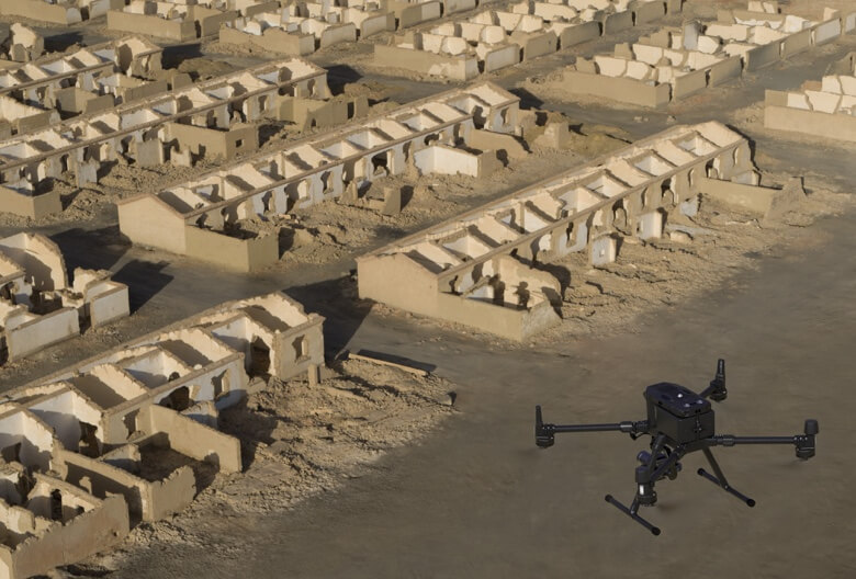
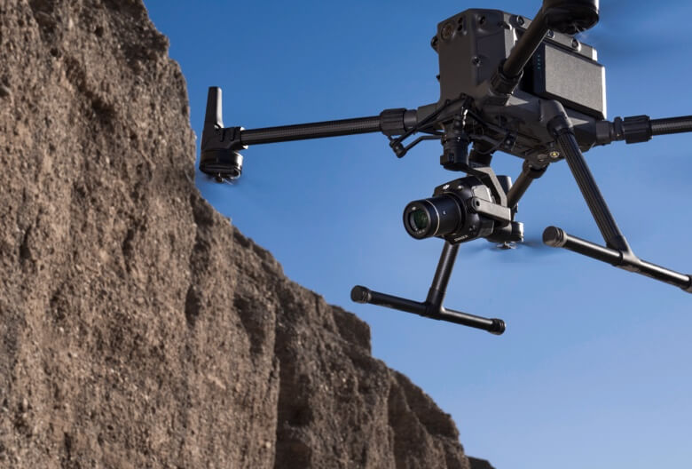
DJI Zenmuse P1 tích hợp cảm biến full-frame với ống kính tiêu cự cố định có thể hoán đổi trên gimbal ổn định 3 trục. Được thiết kế cho các nhiệm vụ bay đo ảnh trắc địa, sản phẩm này nâng hiệu suất và độ chính xác lên một tầm cao mới.
Máy ảnh Full-frame
– Cảm biến Full-frame 45MP – Kích thước điểm ảnh 4,4μm – Hình ảnh có độ nhiễu thấp, độ nhạy cao kéo dài thời gian hoạt động hàng ngày – Chụp ảnh cứ sau 0,7 giây trong suốt chuyến bay – TimeSync 2.0 căn chỉnh máy ảnh, bộ điều khiển bay, mô-đun RTK và gimbal ở cấp độ micro giây
Tính Năng
Độ chính xác không có GCP
3 cm theo chiều ngang / 5 cm theo chiều dọc
Hiệu suất bao phủ cao
3 km² được bao phủ trong một chuyến bay duy nhất
Cảm biến Full-frame
Chất lượng cao lên đến 45 MP
Gimbal ổn định 3 trục
Smart Oblique Capture
Tốc độ màn trập cơ học
Tốc độ màn trập 1/2000 giây
TimeSync 2.0
Đồng bộ hóa ở cấp độ micro giây
Công cụ hỗ trợ của bạn cho phép đo ảnh trên không
Hiệu quả phi thường
P1 bao gồm một cảm biến toàn khung hình, độ nhiễu thấp, độ nhạy cao có thể chụp ảnh cứ sau 0,7 giây trong suốt chuyến bay và bao phủ 3 km2 trong một chuyến bay duy nhất.
Độ chính xác tuyệt vời
Được trang bị màn trập cơ học toàn cầu và hệ thống TimeSync 2.0 hoàn toàn mới, đồng bộ hóa thời gian trên các mô-đun ở cấp độ micro giây, cho phép người dùng ghi lại dữ liệu chính xác đến từng centimet kết hợp với công nghệ bù vị trí và hướng theo thời gian thực.
Linh hoạt mạnh mẽ
Tạo các mô hình 2D, 3D và chi tiết nhờ gimbal 3 trục tích hợp có thể được trang bị ống kính 24/35/50mm và tính năng Smart Oblique Capture.
24mm
35mm
50mm
Nhiều tùy chọn ống kính tiêu cự cố định
– Màn trập cơ học, tốc độ màn trập 1/2000 giây – Gửi xung phơi sáng trung bình tính bằng micro giây – Hỗ trợ ống kính 24/35/50mm với ngàm DJI DL
Chụp xiên thông minh
Bay 7,5 km² chỉ trong một ngày làm việc với P1. Nâng cao hiệu quả cho nhiệm vụ chụp ảnh xiên của bạn bằng tính năng Smart Oblique Capture, trong đó gimbal tự động xoay để chụp ảnh ở các góc độ khác nhau cần thiết. Chỉ những ảnh cần thiết cho việc tái tạo sẽ được chụp ở rìa khu vực bay, giúp tăng hiệu quả hậu kỳ từ 20% đến 50%.
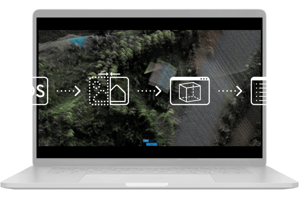
Mission result files are automatically associated with the Mission Name and Mission Time.
A centralized storage location for photos, GNSS data, and TimeStamps.MRK files.
The image metadata contains the camera’s intrinsic and extrinsic parameters and the status of RTK.
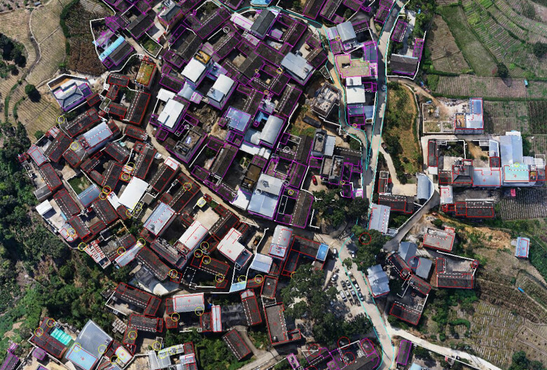
Quản lý dữ liệu thông minh
Quản lý dữ liệu nhiệm vụ của bạn một cách hợp lý.
Báo cáo thực địa
Xác minh chất lượng dữ liệu ngay sau chuyến bay bằng cách kiểm tra dữ liệu vị trí và số lượng hình ảnh thu được, cũng như trạng thái RTK và độ chính xác định vị.
DJI Zenmuse P1
Chế độ nhiệm vụ cho mọi tình huống
Cần tư vấn chuyên sâu về sản phẩm, dịch vụ liên quan thiết bị bay không người lái vui lòng liên hệ Aonic ngay!