Introduction
In the quest to safeguard the diverse and delicate ecosystems that our plant harbors, the application of innovative technologies has emerged as a game-changer in the field of wildlife conservation. Among these trailblazing technologies, one stands out in its ability to soar above the constraints of conventional methods – drones. These unmanned aerial vehicles have swiftly become invaluable allies in the ongoing battle to protect and preserve the earth’s precious wildlife. In this article, we explore how drones are revolutionizing the face of wildlife conservation, ushering in a new era of efficiency, accuracy, and compassion in safeguarding the natural world. From tracking elusive species to monitoring habitats from above, these aerial guardians have become instrumental in shaping a brighter future for both wildlife and humanity. As we delve into the diverse applications and remarkable capabilities of drones in wildlife conservation, we uncover the remarkable impact of these technological wonders on the delicate balance of life in our fragile ecosystems.
What is Wildlife Conservation?
The practice of safeguarding plant and animal species as well as their habitats is known as wildlife conservation. Wildlife, as a component of the world’s ecosystems, contributes to the balance and stability of nature’s processes. The purpose of wildlife conservation is to secure the survival of these species and to educate people how to coexist with other species in a sustainable manner.
Over the last 200 years, the human population has increased tremendously, reaching more than seven billion people now, and it continues to grow swiftly. This means that the planet’s natural resources are being depleted quicker than ever before by billions of people. This expansion and development also jeopardizes the habitats and survival of numerous forms of wildlife around the world, notably animals and plants that may be displaced for land development or consumed for food or other human reasons. Invasive species from other regions of the world, climate change, pollution, hunting, fishing, and poaching are all hazards to wildlife.
National and international organizations such as the World Wildlife Fund, Conservation International, the Wildlife Conservation Society, and the United Nations engage on a variety of fronts to promote global animal and habitat conservation efforts. They collaborate with the government to create and conserve public lands such as national parks and wildlife refuges. They collaborate with law enforcement to prosecute wildlife crimes such as wildlife trafficking and poaching. They also encourage biodiversity in order to support the world’s rising population while protecting existing species and habitats.
10 Benefits of Drones in Wildlife Conservation
| Benefits of Drones in Wildlife Conservation | Description |
|---|---|
| Surveillance and Monitoring | Drones enable aerial surveys to monitor wildlife and habitats, covering vast areas for accurate data collection. |
| Minimizing Disturbance | Non-intrusive drone monitoring allows wildlife to behave naturally, reducing human interference in their habitats. |
| Tracking and Anti-Poaching Efforts | Drones equipped with GPS aid in tracking wildlife and combating poaching activities to protect endangered species. |
| Rapid Response to Threats | Drones assist in emergency situations, identifying stranded animals and assessing damages during natural disasters. |
| Data Collection and Analysis | Aerial data gathered by drones provide insights into wildlife populations, habitat health, and ecological changes. |
| Habitat Mapping and Restoration | Detailed ecosystem maps assist in analyzing habitat degradation and planning targeted conservation efforts. |
| Public Awareness and Education | Captivating drone footage fosters public awareness and understanding of the importance of wildlife conservation. |
| Cost-Efficiency | Drones offer a more affordable option for aerial surveys, making monitoring and research accessible to more groups. |
| Remote Access | Drones can access challenging terrains, providing valuable data on wildlife in remote and inaccessible regions. |
| International Collaboration | Drones facilitate collaboration between conservationists worldwide, leading to a better understanding of global issues. |
Surveillance and Monitoring
Drones equipped with high-resolution cameras and thermal imaging technology have proven to be exceptional tools for monitoring wildlife and their habitats. They enable conservationists to conduct aerial surveys with ease, covering vast areas that would otherwise be difficult or dangerous to access on foot. These aerial surveys provide crucial data on wildlife population sizes, distribution patterns, and migration routes, helping researchers make informed decisions for conservation planning and management.
Minimizing Disturbance
Traditional wildlife surveys often involve human presence, which can disturb animals and alter their natural behavior. Drones, on the other hand, allow researchers to observe wildlife from a distance, reducing the risk of interference and providing more accurate data. The non-intrusive nature of drone monitoring ensures that wildlife can continue their natural activities without disturbance, leading to more authentic observations.
Tracking and Anti-Poaching Efforts
Drones equipped with GPS and radio-tracking capabilities are instrumental in tracking and protecting endangered species. Conservationists can follow the movements of animals in real-time, aiding in anti-poaching efforts and enhancing overall wildlife security. By detecting and responding to poaching activities swiftly, drones serve as powerful deterrents, helping to safeguard vulnerable species from illegal activities.
Rapid Response to Threats
In cases of natural disasters or wildlife emergencies, drones enable swift response and assessment of the situation. They help identify stranded animals, assess damages, and assist in planning rescue missions efficiently. Drones can also provide valuable information to first responders and authorities during events like wildfires or oil spills, allowing for a faster and more coordinated response to minimize the impact on wildlife and their habitats.
Data Collection and Analysis
Drones gather vast amounts of data through aerial imagery and sensors. This data can be processed using advanced algorithms and machine learning techniques, providing valuable insights into wildlife population dynamics, habitat health, and ecological changes. The ability to collect large-scale, high-quality data aids conservationists in making data-driven decisions and developing effective conservation strategies.
Habitat Mapping and Restoration
Drones can create detailed maps of ecosystems, assisting conservationists in analyzing habitat degradation and identifying areas in need of restoration efforts. This allows for targeted conservation strategies and effective allocation of resources. By understanding the state of habitats and the factors impacting them, conservationists can implement restoration projects that help improve biodiversity and ecosystem resilience.
Public Awareness and Education
Captivating aerial footage captured by drones can be used to raise public awareness about wildlife conservation. It provides a unique perspective, allowing people to connect with nature and understand the significance of protecting endangered species and their habitats. Drones can be employed in documentary filmmaking and educational programs, engaging the public and fostering a sense of responsibility towards wildlife conservation.
Cost-Efficiency
Compared to traditional aircraft, drones are more cost-effective, making aerial surveys and wildlife monitoring more accessible to conservation organizations with limited budgets. This cost-efficiency allows conservationists to conduct more frequent surveys over larger areas, leading to a better understanding of wildlife populations and habitat changes over time.
Remote Access
Drones can access remote and challenging terrains, such as dense forests, rugged mountains, and inaccessible coastlines, making it easier to study and protect wildlife in these areas. The ability to access these remote regions provides a comprehensive view of ecosystems and allows researchers to address conservation challenges in previously inaccessible locations.
International Collaboration
Drones facilitate collaboration between international conservation efforts. Researchers from different parts of the world can share data and insights, leading to a more comprehensive understanding of global conservation challenges. Drones can be employed in cross-border initiatives, helping conservationists work together to protect migratory species and address transnational conservation issues effectively.
Real Cases: How Drones Help in Wildlife Conservation
Multispectral and LiDAR data aid in the conservation of Monarch butterfly habitats
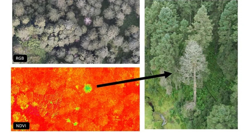
The yearly migration of the Monarch butterfly is one of the world’s most interesting natural events, and it is one of the longest and largest in the insect world, traversing more than 4,000 km. This journey, however, is under danger of extinction due to environmental changes, habitat damage, and deforestation, all of which threaten the monarch’s nesting sites.
The Oyamel fir, the Monarch butterfly’s favored tree for winter hibernation, is particularly vulnerable to an unknown occurrence that causes the tree to turn white, lose its foliage, and die. The monarch butterfly migration phenomenon may be lost forever if these trees continue to decline and no effort is made to safeguard this crucial habitat.
As a result, the Neovolcanic Axis Conservation Fund (FOCEN), an organization dedicated to preserving the ecosystems and forests where monarch butterflies hibernate, is looking for any and all ways to conserve and promote this phenomena. They have turned to LiDAR and multispectral drones in collaboration with Cielito Drone and DJI Enterprise to collect essential forestry data in an effort to conserve these critical habitats.
Working with drones is significantly more efficient and allows them to collect data year after year. A survey that would have taken six days on foot may now be performed in one day using a drone.
Fawn protection against industrial mowers
A female deer gives birth to one or two fawns between late April and early Summer, which she protects from predators by nesting in long grasses of meadows and even domestic lawns. Unfortunately, these breeding patterns conflict with farmers’ need to hay meadows. A mower operator will almost certainly miss the small form of a newborn deer hidden in the dense grass. To make matters worse, when faced with danger, a fawn’s natural reaction is to sit totally still, making it much more difficult for the mower operator to avoid killing or gravely injuring them.
And there are some unsettling statistics to back this up: it is believed that about 90,000 fawns are killed by mowing machinery in Germany alone each year, with similar figures reported across Europe, from Norway to the Netherlands.
Until now, the only solution to this problem has been for teams of farmers and dogs to personally examine every field for nests – a time-consuming, not to mention hit-or-miss procedure due to the difficulties of seeing the deer.
A brilliant solution to the fawn problem is to fly a thermal drone over the fields before they are mowed, such as a Matrice 30T or a Mavic 3T. The drone can easily and quickly detect the fawns’ heat signatures, allowing conservationists to transport them to safety before the mowers drive through.
Koala Search and Rescue
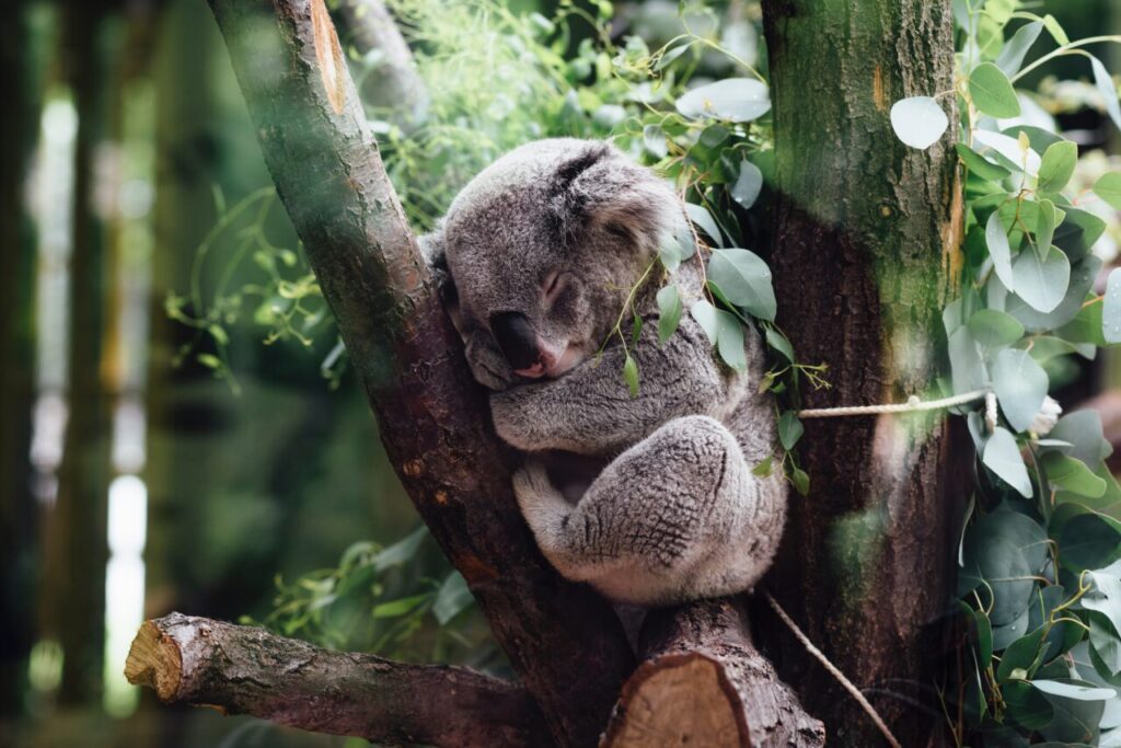
For good cause, WWF-Australia describes the 2019-20 Australian bushfires as “one of the worst wildlife disasters in modern history.” The extraordinary fire season across the continent burnt almost 12.6 million hectares of land, killing or displacing nearly 3 billion animals. More over 61,000 of these were koalas, Australia’s renowned marsupials.
Even before the bushfires, the much-loved koala was deemed endangered because to risks posed by poaching, land development, food degradation, droughts, and disease. So, while the fires raged, forest and wildfire officers rapidly turned to drones to find surviving koalas in both burned and unburned areas.
The rescue crew in Victoria used DJI’s Mavic 2 Enterprise Series drones equipped with high-resolution thermal cameras to detect the heat signatures of the koalas. Once the bears were identified, the same drone’s ultra-zoom visual camera assisted first responders in determining whether the animals required medical assistance. Cherry pickers were utilized to bring down anyone in need of assistance.
Wildlife mapping thermal drones were significantly cheaper and more efficient than traditional surveying methods such as scat surveys or spotlighting with head lamps, according to researchers in the neighbouring state of New South Wales. This is because, despite being instantly recognisable, koalas camouflage extremely well and are notoriously difficult to identify.
Thermal drones, interestingly, have emerged as a formidable weapon in other areas of firefighting as well. No other developing technology has benefited firefighter and public safety as much as thermal imaging drones have, from spotting invisible hotspots and avoiding subsequent flames to gathering wildfire data at night.
Conclusion
In the realm of wildlife conservation, drones have emerged as groundbreaking and indispensable allies, revolutionizing the way we protect and preserve the natural world. Through their ability to soar above the limitations of conventional methods, these unmanned aerial vehicles have brought about a multitude of benefits, reshaping the landscape of conservation efforts.
From conducting efficient aerial surveys to minimizing disturbance and interference, drones have elevated the precision and accuracy of wildlife monitoring. They provide a non-intrusive means of observing and understanding the behavior of animals, allowing for more authentic and reliable data collection.
Perhaps one of the most critical roles drones play is in the fight against wildlife poaching. Equipped with advanced tracking technologies, they serve as powerful tools to combat illegal activities, protecting endangered species and restoring a sense of security to delicate ecosystems.
Moreover, drones’ rapid response capabilities prove vital in emergency situations, providing valuable information during natural disasters and enabling timely interventions to minimize the impact on wildlife and their habitats.
The wealth of data gathered by drones aids in comprehensive analyses, facilitating informed decision-making in conservation planning and habitat restoration. Their cost-efficiency allows conservation organizations with limited resources to conduct frequent aerial surveys over vast areas, contributing to a better understanding of wildlife populations and ecological changes.
Furthermore, drones hold the potential to bridge the gap between the public and the natural world, captivating hearts and minds through stunning aerial footage. By fostering public awareness and education, drones inspire a deeper connection to wildlife, igniting a collective responsibility to safeguard our planet’s biodiversity.
As these unmanned aerial vehicles continue to evolve and establish themselves as indispensable tools, international collaboration in wildlife conservation has taken a significant stride forward. Researchers from diverse regions can now share data, knowledge, and experiences, laying the groundwork for a more holistic and united approach to global conservation challenges.
While drones have undoubtedly opened up new frontiers in wildlife conservation, it remains essential to balance technological progress with ethical considerations. Respecting wildlife and their habitats should remain paramount in our endeavors to protect and cherish the extraordinary diversity that thrives on Earth.
In conclusion, drones represent a transformative force in the pursuit of preserving the delicate balance of life in our ecosystems. As they soar to new heights, it is with hope and determination that these unmanned aerial vehicles will continue to pave the way for a brighter future, where humans and wildlife coexist harmoniously, safeguarding the irreplaceable wonders of nature for generations to come.
References
How conservation drones track wildlife and empower environmentalists to protect endangered species

