Precision agriculture refers to a scientific approach that leverages advanced sensor and analysis tools to improve crop yields and assist in making informed management decisions. Unmanned Aerial Vehicles (UAVs) have become a widely used application in precision agriculture. The use of high-resolution UAV imagery enables early and cost-effective identification, diagnosis, and remediation of agricultural issues compared to low-resolution satellite imagery. This modern method empowers farmers to optimize inputs like water and fertilizer to enhance productivity, quality, and yield. To achieve this, a substantial amount of high-resolution data on crop conditions and health during the growing season is essential.
The ultimate goal of precision agriculture is to provide farmers with valuable support in managing their operations. This support comes in various forms, but the common outcome is a reduction in the need for resources. UAVs play a crucial role in meeting farmers’ needs and aiding them in making better management decisions at minimal costs and with less environmental impact.
Precision agriculture relies on various technologies in UAV systems, including GPS, drones, and satellite images. This data provides farmers with information on key aspects such as crop status, weather forecasts, and environmental changes. One essential distinction between precision farming and traditional agriculture is the ability to manage fields as distinct zones rather than treating them as a single unit. This zoning approach allows for more diversified and tailored management decisions for different parts of the fields, such as adjusting fertilizer amounts, optimizing machinery movements, and using fuel efficiently.
Why is Precision Agriculture Important?
Precision agriculture is a novel idea embraced globally, aimed at boosting productivity, minimizing labor efforts, and optimizing the management of fertilizers and irrigation practices. This approach heavily relies on extensive data and information to enhance the utilization of agricultural resources, crop yields, and overall crop quality. The primary beneficiaries of precision agriculture are two major sectors:
Agricultural Sector
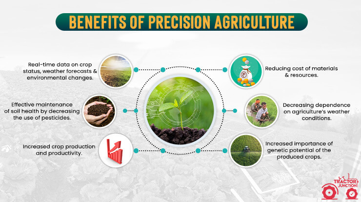
Farmers and businesses have the opportunity to optimize their efforts and resources, leading to reduced consumption and waste while increasing the productivity of their land. This optimization also translates to increased profitability for farmers and contractors, as processes are managed more efficiently, resulting in reduced hourly costs and less strain on human resources. This significant improvement in crop efficiency not only saves on financial expenses but also leads to higher production levels.
Although precision agriculture technologies may appear costly initially, the long-term savings far outweigh those of traditional agricultural methods. Precision agriculture allows growers to precisely calculate the required amount of fertilizer and select the most effective types for specific areas. Additionally, these technologies play a crucial role in improving the planning of agricultural operations over an extended period, enabling real-time adjustments during unforeseen circumstances or emergencies.
The Environment
Precision agriculture also benefits the environment, and it is vital to recognize the interconnection between agricultural practices and environmental conditions. Implementing precision agriculture offers numerous advantages in this regard. It has been proven effective in reducing wastage of fertilizers, herbicides, emissions, and soil compaction, as it enables a more rational and precise allocation of resources. Moreover, precision agriculture helps to reduce the reliance on weather conditions, ensuring a more stable agricultural output.
Another crucial benefit is the maximum utilization of the genetic potential of crops, resulting in improved yields and higher-quality produce. By optimizing soil use, precision agriculture helps preserve soil quality, contributing to a sustainable food supply. As a result, precision farming plays a vital role in addressing the global issue of hunger.
In addition to its environmental impact, precision agriculture also allows farmers to significantly enhance the quality of their products while simultaneously reducing production costs.
Precision Agriculture Technologies And Methods
Precision farming necessitates specialized equipment and software to gather and analyze all the relevant information. As precision agriculture relies on both hardware and software components, it requires skilled specialists for initial implementation. Nevertheless, with ongoing training and experience, farmers can eventually manage the technology independently. Precision farming technology can be categorized into three main types: ground-based, aerial, and satellite-based systems.
Ground-based technology is well-suited for tasks such as production planning, mapping, scouting, and machine control. On the other hand, aerial and satellite technologies are more applicable to addressing broader challenges, like real-time yield analysis from any location. To ensure comprehensive and accurate data, it is recommended to integrate a mix of these technologies such as drones.
Drones in Precision Agricultural
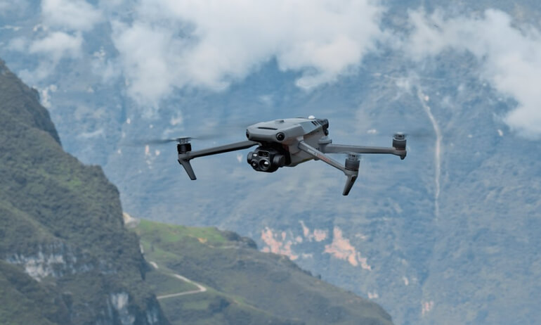
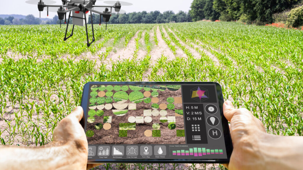
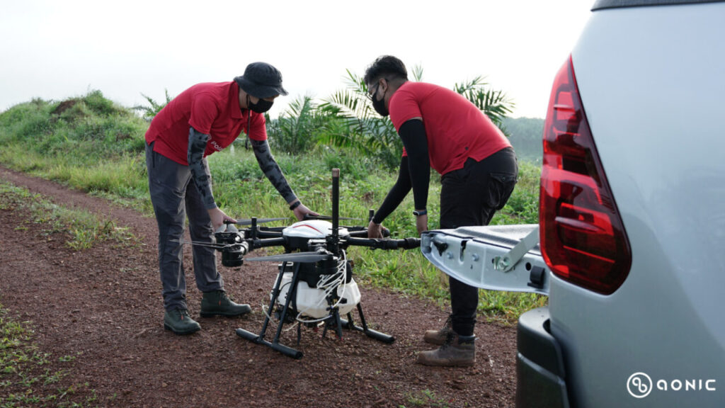
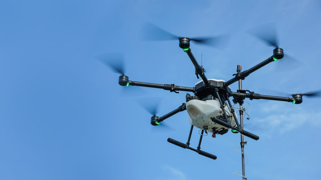
Aerial technologies for crop management rely on unmanned aerial vehicles (UAVs), which enable farmers to monitor crop conditions without physically scouting all fields. The most straightforward approach involves using agricultural drones, which farmers already employ for tasks like watering, seeding, and applying pesticides. By equipping these drones with a hyperspectral camera as a payload, they can capture the necessary information. However, this method requires a qualified pilot, incurring additional costs.
Certain drones come with built-in programs designed to cater to various agricultural precision spraying needs, depending on the type of plantation, such as oil palm or paddy. An innovative solution from Malaysia, Oryctes, offers efficient and cost-effective spraying for Southeast Asian growers. Utilizing the latest agrotechnology, drones can automate the spraying workflow on farms. Oryctes is the first high-accuracy point-to-point agriculture spraying drone specifically designed for oil palm plantations, effectively combating damaging pests like Rhinoceros Beetles. By incorporating RTK positioning technology and a unique single-nozzle design, Oryctes ensures spraying with centimeter-level precision. This level of control allows farmers to precisely regulate the quantity and area of spraying, minimizing the use of excessive pesticides while optimizing results.
Using Oryctes which is built for precision agriculture is a more progressive solution. It is controlled remotely and consumes less fuel. Moreover, precision agriculture drones can analyze the field thoroughly, conducting complex multispectral, thermal, and hyperspectral soil analyses.
Global Positioning System (GPS)
The Global Positioning System (GPS) is a satellite-based navigation system that offers location and time information worldwide, regardless of weather conditions and geographical location. In precision agriculture, GPS plays a vital role by providing accurate location data for mapping and navigation purposes.
A primary application of GPS in precision agriculture involves mapping and data collection at the field level. Farmers can utilize GPS receivers installed on their vehicles or equipment to gather data on the precise location, shape, and size of their fields. Additionally, specific features within the fields, such as irrigation systems, drainage ditches, and fence lines, can also be located using GPS. This data is then used to generate detailed field maps, facilitating the planning and scheduling of field operations, the implementation of variable rate technology for agricultural inputs, and the analysis of field performance.
Furthermore, GPS-based guidance systems enable farmers to navigate their vehicles and equipment with exceptional accuracy, minimizing the risk of errors and enhancing overall operational efficiency in the fields.
Geographic Information Systems (GIS)
A geographical information system (GIS) is a computer software database system that enables the input, storage, retrieval, analysis, and display of geographical information with reference to maps.
In precision agriculture, GIS serves the purpose of creating, storing, and analyzing spatial data pertinent to farming activities. This data may encompass field boundaries, topography, soil types, crop varieties, and other relevant features. Farmers can leverage GIS to determine the most suitable locations for planting specific crops and to identify areas that might be more susceptible to pests or diseases. The division of zones based on soil type, nutrient availability, soil moisture content, pH levels, and pest infestation is traditionally analyzed using a combination of GIS and GPS.
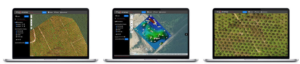
Some GIS software would be the Airamap Desktop, an advanced aerial mapping analytics software. Airamap Desktop is used in industrial applications to monitor your on-site situation so you can do swift and accurate decision-making. Airamap is equipped with an artificial intelligence (AI) data processing engine that cut the processing time short while maintaining the quality of the processed results.
You can then sort your results into many kinds of models and map types such as DTM, DSM, DEM, heat map, and many more. These reports are extremely useful in determining necessary preventive actions, enhancing operations, and at the same time, reducing operational and time costs.
Airamap Desktop works great with the Oryctes Flight App, designed specifically for the Oryctes Point-to-Point spraying drone, which allows for the importation of mission files, facilitating automatic waypoint generation. The app also ensures precision and accuracy by employing Automatic Basepoint File Verification, working in conjunction with the new Oryctes Base Station, thus mitigating any concerns about incorrect base point coordinates. Additionally, the app permits the adjustment of mission altitude and spray time, enabling spot spraying to meet specific requirements.
In precision agriculture, the utilization of GIS allows farmers to access various records, including soil survey maps and information about typical plant characteristics cultivated in the area. Additionally, satellite images and aerial photographs offer supplementary data. Another valuable capability of GIS is the ability to analyze numerous farm management possibilities by comparing and manipulating different data layers.
Oil Palm Industry in Malaysia
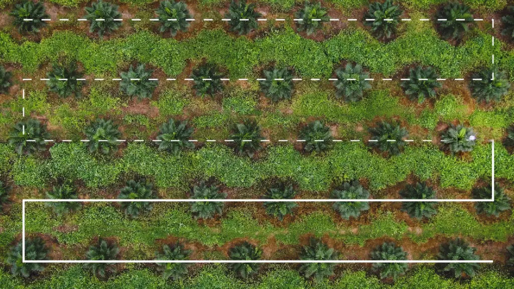
In Malaysia’s oil palm industry, the adoption of precision agriculture is no longer considered uncommon; instead, it is actively promoted due to its numerous advantages. The oil palm sector heavily relies on point-to-point spraying, where liquid substances are applied in a targeted and spatially distributed manner to trees and soil, ensuring a healthy environment for the plantation.
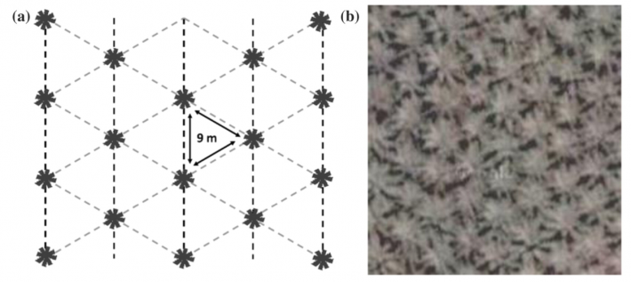
Moreover, the oil palm industry’s monoculture planting practices and distinctive topographical pattern allow individual oil palm trees to be easily distinguishable from other trees when observed through satellite imagery. This uniform arrangement of plants creates a necessity for precision agriculture, especially given the large field size. The implementation of precision agriculture has significantly aided in managing extensive oil palm field areas, facilitating daily operations such as harvesting, maneuvering, pruning, and weeding to be conducted with meticulous attention to detail.
Paddy Industry in Malaysia
Among paddy farmers, the adoption of modern farm management tools is considered to be at a moderate level, with the highest level of technology being used for tasks like fertilizing, plowing, and seeding. The potential for implementing precision agriculture practices has been observed to be more feasible in granary areas managed by large cooperatives or cooperatives.
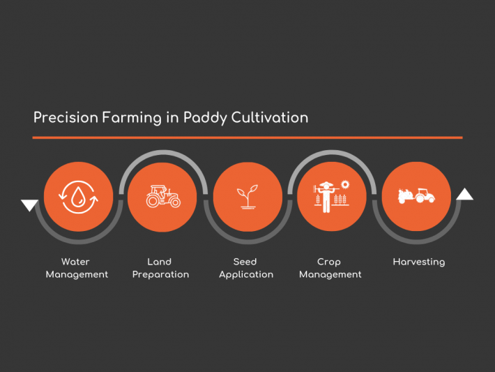
By incorporating geospatial variabilities for paddy fields, the four main processes of paddy cultivation in Malaysia can be monitored and efficiently managed. Water management plays a crucial role in achieving a balance that considers various factors such as supporting canal systems, hydraulic units, rice field conditions, field off-take, and the appropriate inflow and farming practices.
In terms of land preparation, a thorough understanding of the graphical features of the soil is essential to ensure effective agronomic, soil, and crop management. Ideally, having flat and uniformly leveled land helps to establish a uniform crop and provides adequate protection against weed competition when the fields are flooded. The same concept of precision agriculture is also applied in seed application, crop management, and harvesting.
Conclusion
Precision agriculture technologies and their implementation in farming are continually pushing boundaries and have the potential to address challenges faced in traditional farming practices. Currently, new sensors and software packages are constantly being developed to enhance drone flight planning. This dynamic nature necessitates that protocols for best-practice UAV-based approaches remain live documents to prevent rapid obsolescence.
Moreover, due to the diverse range of agricultural applications, each with its own requirements and challenges, there is a need for exploratory investigation to optimize results. In the initial processing of orthomosaics, users have to choose from various processing options.
Additionally, unmanned aerial systems (UAS)-based mapping approaches, such as assessing phenotypic traits, monitoring crop growth, or predicting yield before harvest, can be conducted through various methods, including simple regression techniques and vegetation indices, as well as object-based image analysis approaches.