Introduction
Ocean conservation, the practice of protecting and preserving marine ecosystems and their biodiversity, is a critical endeavor in the face of growing environmental challenges. From climate change to plastic pollution, our oceans are under threat like never before. As we strive to secure the health and vitality of our oceans, innovative technologies are playing an instrumental role. Drones, often associated with capturing stunning aerial footage and performing various tasks from the skies, have emerged as powerful tools in the field of conservation. In this article, we delve into the remarkable advantages that drones offer in revolutionizing marine conservation efforts, and how their unprecedented impact is shaping a brighter future for our marine ecosystems,
What is Ocean Conservation in the Drone Era?
Ocean conservation encompasses a range of activities aimed at preserving marine life, habitats, and ecosystems. It involves scientific research, policy advocacy, community engagement, and practical initiatives to address the numerous threats that our marine face. From overfishing and habitat destruction to coral bleaching and pollution, the challenges are vast and interconnected. In this context, drone technology has ushered in a new era of ocean conservation, providing scientists, researchers, and conservationists with innovative tools to study, protect, and restore marine environments.
Advantages of Using Drones in Ocean Conservation Efforts & Real Life Examples
| Advantages of Drones in Ocean Conservation | Examples of Successful Drone Applications |
|---|---|
| Aerial and Underwater Exploration | Woods Hole Oceanographic Institution used underwater drones to explore deep-sea hydrothermal vents and discover new ecosystems. |
| Remote Sensing and Data Collection | Oceans Unmanned, Inc. and The Ocean Cleanup employed drones to survey the Great Pacific Garbage Patch, mapping plastic pollution |
| Biodiversity Monitoring | The Australian Institute of Marine Science utilized drones to monitor and safeguard vulnerable dugongs and turtles in the Great Barrier Reef Marine Park. |
| Conservation Area Surveillance | Drones were employed in the Galápagos Islands to monitor and prevent illegal fishing activities, ensuring protection of unique marine species within the reserve. |
| Rapid Response to Environmental Crises | Aerial drones assessed the extent of the Deepwater Horizon oil spill, aiding informed decisions and immediate response efforts to mitigate the disaster’s impact. |
| Public Engagement and Awareness | BBC’s “Blue Planet II” series enthralled global audiences with stunning drone footage, catalyzing discussions about marine conservation and the urgency of ocean protection. |
| Reduced Disturbance to Wildlife | NOAA used drones to study humpback whale behavior without causing undue stress to the animals, providing insights into their natural interactions. |
| Adaptability to Different Environments | Researchers studying Arctic ice formations employed drones to gather critical insights into climate change’s impact on polar regions. |
| Efficient Mapping and Surveying | The Catlin Seaview Survey generated panoramic images of coral reefs using underwater drones, aiding ongoing monitoring and management efforts. |
| Scientific Innovation | Marine biologists at Duke University employed drones to study shark behavior from above, revealing insights into their interactions and behaviors in the wild. |
| Collaboration and Information Sharing | The Global Ocean Observing System (GOOS) collaborates with partners globally to utilize drones for collecting oceanographic data, contributing to a comprehensive understanding of ocean health. |
Aerial and Underwater Exploration
Drones are a unique innovation that seamlessly traverse both the skies and the depths of our oceans. With specialized sensors and cameras, drones capture invaluable data and imagery from above and below the water’s surface, offering a holistic view of marine ecosystems.
Example:
Woods Hole Oceanographic Institution employed underwater drones to uncover hidden deep-sea ecosystems, shedding light on species that thrive in extreme conditions.
Remote Sensing and Data Collection
Gathering data from remote and challenging oceanic locations has always been a hurdle. Drones equipped with cutting-edge technology facilitate remote sensing, collecting real-time information on water quality, temperature, and more. This data enhances our comprehension of marine health and informs conservation decisions.
Example
Oceans Unmanned, Inc. and The Ocean Cleanup, two environmental nonprofit organizations, are collaborating to map areas of the gyre. They will utilize both quantitative images and qualitative data acquired to determine the optimal methods of collecting rubbish from the ocean and transporting it back to land.
Oceans Unmanned, for its part, will launch Aeromao Talon Amphibious drones from Ocean Cleanup ships for two-hour survey missions. To maximize mission duration and data collection, the craft will make water landings and be recovered by smaller boats once the batteries are depleted. The mapping imagery they return will be analyzed using an automated neural network for object detection, as well as used to devise the most effective collection methods.
Ocean Cleanup, which was founded in 2013 to combat the rising tide of oceanic trash, will debut its third, updated version of the equipment it has built to capture floating litter. Much of that rubbish is small and difficult to detect and collect. The group believes that bringing smart eyes in the sky, which unmanned aerial aircraft (UAS) provide, will be critical to bolstering its efforts.
Biodiversity Monitoring
Monitoring marine species is crucial for conservation efforts. Drones equipped with high-resolution cameras capture captivating images and videos of marine life, aiding population assessments, tracking migrations, and identifying endangered species.
Example
The Australian Institute of Marine Science employed drones to safeguard vulnerable dugongs and turtles in the Great Barrier Reef Marine Park, monitoring their behaviors and habitats.
The researchers had previously counted turtles as they landed on the beach to lay eggs (about 23,000 in a single night) and marked the creatures with non-toxic dissolving paint to better monitor them in the water. However, they find it difficult to count accurately with thousands of painted and unpainted turtles from a small boat in a rough weather. Therefore, they think using a drone is much easier and more accurate, and the data can be stored instantly and permanently.
Conservation Area Surveillance
Drones are integral to the effective management of marine protected areas (MPAs). With their ability to cover vast areas efficiently, drones monitor and enforce regulations, detect illegal fishing activities, and protect critical habitats.
Example
The Galapagos Islands are home to some of the world’s most distinctive and endangered fauna. Drones have become more popular instruments for conservation and research initiatives in recent years. Drones assist scientists in better understanding the behavior and habitats of species in the Galapagos Islands, and they can be used for a variety of objectives, including monitoring animal populations and detecting poachers and illicit fishing.
Rapid Response to Environmental Crises
When environmental disasters strike, swift action is imperative. Drones offer rapid assessment capabilities, surveying affected areas and providing real-time data to response teams, facilitating targeted interventions to minimize ecological damage.
Example
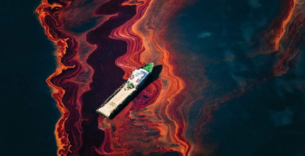
One of the most catastrophic environmental disasters in recent history, the Deepwater Horizon oil spill, unfolded in 2010 when an offshore drilling rig suffered a catastrophic explosion and sank in the Gulf of Mexico. This tragedy resulted in a massive oil spill that unleashed millions of barrels of crude oil into the ocean, wreaking havoc on marine ecosystems, coastal communities, and economies.
In the face of this unprecedented disaster, the need for accurate and timely information was paramount to mitigate the impact and guide response efforts. This is where aerial drones emerged as vital tools in the arsenal of disaster response and environmental assessment.
As the aerial drones soared above the Gulf of Mexico, they captured high-resolution images and video footage of the oil spill’s extent. This visual data allowed experts to estimate the size of the spill, track its movement, and identify areas most affected by the oil slick. By creating detailed maps of the affected regions, authorities gained a comprehensive understanding of the disaster’s scope, enabling them to allocate resources efficiently and prioritize response efforts.
The data collected by the aerial drones provided crucial insights into the spread of the oil and its potential impact on marine life, coastal ecosystems, and the local economy. These insights informed the decisions of response teams, guiding them to deploy containment booms, skimmers, and dispersants to mitigate the damage and prevent further contamination.
Public Engagement and Awareness
Drones possess a unique ability to capture breathtaking footage that resonates with the public. By sharing these visuals through media and documentaries, drones raise awareness about marine conservation issues and inspire a deeper connection to our oceans.
Example
In 2017, the documentary series “Blue Planet II” captured the hearts and minds of audiences worldwide, not only for its captivating storytelling but also for its visually mesmerizing depiction of marine life and ecosystems. A significant contributor to the series’ impact was the innovative use of drone technology to capture breathtaking aerial and underwater footage, offering viewers a glimpse into the hidden wonders of our oceans.
The incorporation of drones into “Blue Planet II” marked a transformative moment in the portrayal of marine environments on screen. These unmanned aerial and underwater vehicles allowed the filmmakers to capture scenes that were previously inaccessible or rarely witnessed by the human eye. From sweeping aerial shots of marine landscapes to intimate underwater encounters with elusive creatures, the drone-captured imagery added a new dimension to the storytelling, evoking awe and appreciation for the beauty and complexity of ocean ecosystems.
The stunning drone footage showcased in “Blue Planet II” had a profound impact that extended beyond mere visual spectacle. It catalyzed discussions about marine conservation and the urgency of ocean protection on a global scale. The visuals conveyed the fragile balance of marine life, the interconnectedness of species, and the profound impacts of human activities on these delicate ecosystems.
Reduced Disturbance to Wildlife
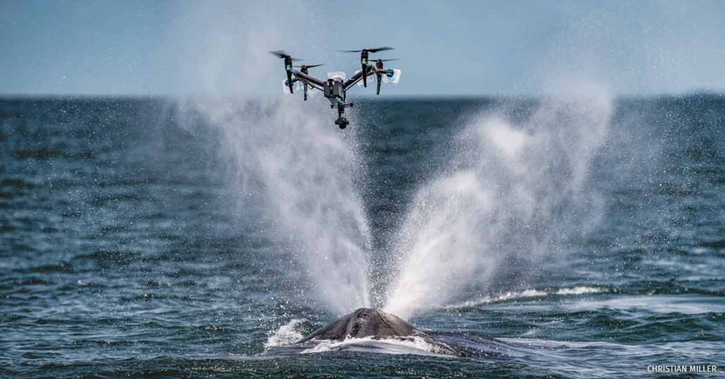
Drones have emerged as game-changers in wildlife observation, particularly in sensitive marine environments. The use of drones enables researchers to study animals with minimal intrusion, allowing for a more comprehensive understanding of their natural behaviors without causing undue stress.
Example
The National Oceanic and Atmospheric Administration (NOAA) harnessed the power of drones to study humpback whale behavior. Traditionally, studying marine mammals involved approaching them with boats or aircraft, which could lead to disturbance altering their behaviors. However, drones offer a non-invasive approach. By flying drones above the whales, researchers obtained valuable aerial footage that captured their behaviors in their natural habitat. This innovative techniques allowed scientists to monitor social interactions, mating behaviors, and even the effects of external factors like boat traffic without causing the whales any distress. The result was a wealth of insights into humpback whale behavior that informed conservation strategies and minimized the human impact on these majestic creatures.
Adaptability to Different Environments
Drones are uniquely adaptable to various marine environments, making them essential tools for studying remote and challenging regions that are difficult for humans to access. From polar ice to tropical coral reefs, drones can venture into diverse settings, providing crucial data on environmental changes and ecosystem dynamics.
Example
Researchers focused on the impacts of climate change on Arctic ice formations utilized drones to gather critical insights. In polar regions, the effects of warming are pronounced, leading to shifting ice patterns and altered habitats. Drones equipped with advanced sensors and cameras enabled researchers to survey ice formations from above, capturing data on ice thickness, movement, and changes in topography. By flying over vast areas, drones provided a comprehensive view of the changing Arctic landscape. this information is vital for understanding the rate of ice melt and its implications for sea level rise, marine ecosystems, and global climate patterns
Efficient Mapping and Surveying
Mapping and surveying underwater environments have traditionally been labor-intensive and challenging endeavors. Drones equipped with imaging technology revolutionize this process, offering efficient and accurate ways to create detailed maps of underwater terrains and structures.
Example
The Catlin Seaview Survey employed underwater drones to generate panoramic images of coral reefs around the world. These panoramic images, akin to underwater Google Street View, provided researchers with an unprecedented view of coral ecosystems. By stitching together these images, scientists gained insights into the health of coral reefs, identified areas of stress or degradation, and monitored changes over time. The efficiency of drone-based mapping allowed for more frequent and extensive monitoring efforts, supporting ongoing conservation and management initiatives to protect these vital marine habitats.
Scientific Innovation
Drones are driving innovation in scientific research, enabling new methodologies and data collection approaches that were previously unattainable. They allow researchers to collect data from unique perspectives, enhancing our understanding of complex ecological interactions.
Example
Marine biologists at Duke University harnessed drones to study shark behavior from above, unveiling new insights into their interactions and behaviors in the wild. Traditional methods of studying sharks often involved direct observation or tracking tags, but drones provided a bird’s-eye view that transformed the understanding of these apex predators. By observing from above, researchers could gather data on hunting behaviors, social dynamics, and patterns of movement. This innovative approach opened up new avenues of research, revealing the nuances of shark behavior that were previously hidden beneath the surface.
Collaboration and Information Sharing
Drones facilitate collaboration among researchers, institutions, and organizations across the globe. By haring data and insights, the global community can work together to address complex challenges and improve our collective understanding of ocean health.
Example
The Global Ocean Observing System (GOOS) exemplifies the collaborative potential of drones in ocean conservation. By collaborating with partners worldwide, GOOS utilizes drones to collect oceanographic data from various regions. These data contribute to a comprehensive understanding of ocean dynamics, temperature changes, currents, and biodiversity. The collaborative nature of GOOS‘s efforts, made possible by drone technology, enhances our ability to monitor and respond to changes in ocean conditions, contributing to more informed decision-making and conservation efforts on a global scale.
Conclusion
Drones are rewriting the playbook of ocean conservation, offering advantages that transcend traditional methodologies. From enhancing exploration and monitoring to promoting public engagement and driving scientific innovation, drones are pivotal allies in our mission to safeguard marine ecosystems. As technological advancements continue and collaborations thrive, the horizon for revolutionizing ocean conservation expands further. With drones by our side, we have the means to preserve the life-giving oceans and secure a thriving future for our planet’s blue heart.